iFANN
    iFANN'da ara...
    Giriş Yap
    Ana Sayfa
    Haberler
    Videolar
    Fotoğraflar
    GIF'ler
    Keşfet
    Anketler
    Ödüller
    iFAMOUS
    Viki
    Anime
    Odalar
    Bildirimler
    Mesajlar
    Yer İmleri
    Profil
    VikiÖdülleriFAMOUSSıralamalarSektörlerİçerik Üretici ÖdülleriKullanıcı ÖdülleriŞartlarGizlilikTopluluk KurallarıKaldırma / DMCAYardımGeliştiriciler

    © 2026 iFANN

    Ana Sayfa
    Ara
    Mesajlar
    Uyarılar
    Profil
    Fotoğraf
    Scarlett S
    Scarlett S@scarlett_s1mo
    💭News💭Info/Editorials
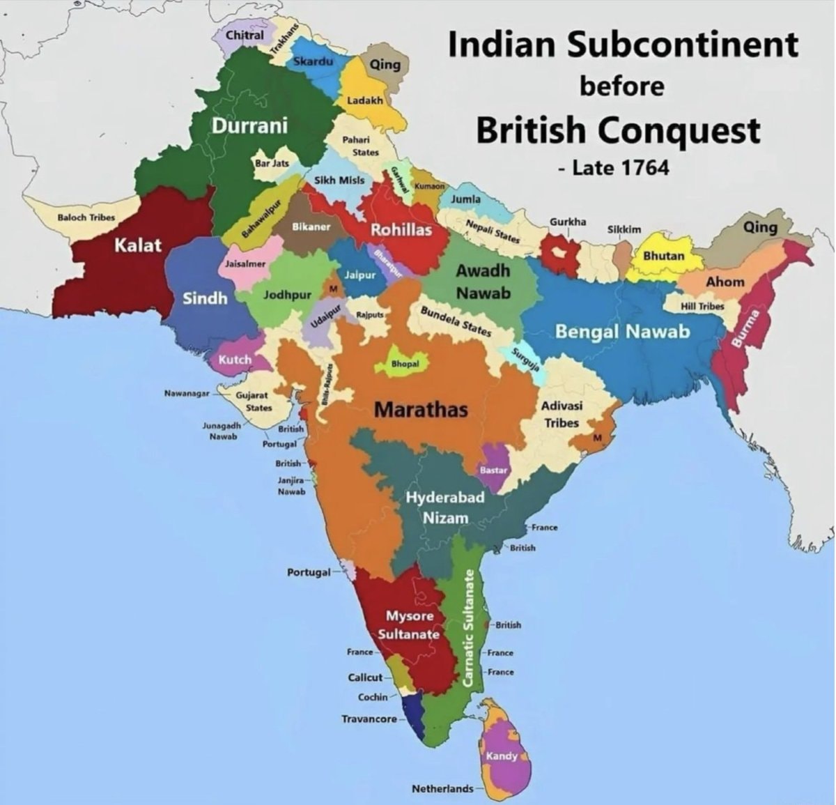
    India map late 1764 before British conquest

    @scarlett_sA map of india from late 1764, before the british conquest. it shows territories like durrani, kalat, sindh, kutch, marathas, hyderabad nizam, mysore sultanate, bengal nawab, and awadh nawab. european colonial areas like british, portuguese, french, and netherlands are also marked

    Orijinal gönderiyi gör

    India map late 1764 before British conquest

    @scarlett_s tarafından fotoğraf· Jul 26, 2026· News

    Bu fotoğraf hakkında

    The image is a historical map of the Indian subcontinent. It shows various regions and kingdoms before the British conquest, specifically labeled as "Late 1764." The map uses different colors to delineate territories such as Durrani, Kalat, Sindh, Kutch, Marathas, Hyderabad Nizam, Mysore Sultanate, Bengal Nawab, and Awadh Nawab. The style is informational and educational, with clear labels for each region and some smaller territories. A notable detail is the presence of European colonial territories like British, Portuguese, French, and Netherlands marked on the map. The title "Indian Subcontinent before British Conquest - Late 1764" is prominently displayed at the top right.

    Tüm News fotoğraflarını gör

    ?

    Henüz yorum yok. İlk yorumu sen yap!

    Daha fazla News fotoğrafı

    Tüm News fotoğraflarını gör
    NYPOST mugshot for community notesNYPOST mugshot for community notesChile map with factsChile map with factsStephen Schork on US energy reservesStephen Schork on US energy reservesTrump Triumphal Arch proposal2Trump Triumphal Arch proposalNew Hampshire man returns overdue book2New Hampshire man returns overdue bookIn-N-Out manager salary2In-N-Out manager salaryWaymo car police arrestWaymo car police arrestTrump smiling outdoors2Trump smiling outdoorsMarie Marc breast cancer firing settlement2Marie Marc breast cancer firing settlementRussia and China veto Iran sanctions panelRussia and China veto Iran sanctions panelMamdani snow shovel wage hike2Mamdani snow shovel wage hikeKyle Kuzma on SudanKyle Kuzma on SudanIRGC Navy commander Ali Asghari on HormuzIRGC Navy commander Ali Asghari on HormuzGenetically engineered mice with human cells2Genetically engineered mice with human cellsUKMTO warning Strait of HormuzUKMTO warning Strait of HormuzChilean tree daisy conservation effort2Chilean tree daisy conservation effortIsraeli strikes on Nabatieh South LebanonIsraeli strikes on Nabatieh South LebanonElon Musk Tennessee data center advisory2Elon Musk Tennessee data center advisory
    Fotoğraf
    Scarlett S
    Scarlett S@scarlett_s1mo
    💭News💭Info/Editorials
    India map late 1764 before British conquest

    @scarlett_sA map of india from late 1764, before the british conquest. it shows territories like durrani, kalat, sindh, kutch, marathas, hyderabad nizam, mysore sultanate, bengal nawab, and awadh nawab. european colonial areas like british, portuguese, french, and netherlands are also marked

    Orijinal gönderiyi gör

    India map late 1764 before British conquest

    @scarlett_s tarafından fotoğraf· Jul 26, 2026· News

    Bu fotoğraf hakkında

    The image is a historical map of the Indian subcontinent. It shows various regions and kingdoms before the British conquest, specifically labeled as "Late 1764." The map uses different colors to delineate territories such as Durrani, Kalat, Sindh, Kutch, Marathas, Hyderabad Nizam, Mysore Sultanate, Bengal Nawab, and Awadh Nawab. The style is informational and educational, with clear labels for each region and some smaller territories. A notable detail is the presence of European colonial territories like British, Portuguese, French, and Netherlands marked on the map. The title "Indian Subcontinent before British Conquest - Late 1764" is prominently displayed at the top right.

    Tüm News fotoğraflarını gör

    ?

    Henüz yorum yok. İlk yorumu sen yap!

    Daha fazla News fotoğrafı

    Tüm News fotoğraflarını gör
    NYPOST mugshot for community notesNYPOST mugshot for community notesChile map with factsChile map with factsStephen Schork on US energy reservesStephen Schork on US energy reservesTrump Triumphal Arch proposal2Trump Triumphal Arch proposalNew Hampshire man returns overdue book2New Hampshire man returns overdue bookIn-N-Out manager salary2In-N-Out manager salaryWaymo car police arrestWaymo car police arrestTrump smiling outdoors2Trump smiling outdoorsMarie Marc breast cancer firing settlement2Marie Marc breast cancer firing settlementRussia and China veto Iran sanctions panelRussia and China veto Iran sanctions panelMamdani snow shovel wage hike2Mamdani snow shovel wage hikeKyle Kuzma on SudanKyle Kuzma on SudanIRGC Navy commander Ali Asghari on HormuzIRGC Navy commander Ali Asghari on HormuzGenetically engineered mice with human cells2Genetically engineered mice with human cellsUKMTO warning Strait of HormuzUKMTO warning Strait of HormuzChilean tree daisy conservation effort2Chilean tree daisy conservation effortIsraeli strikes on Nabatieh South LebanonIsraeli strikes on Nabatieh South LebanonElon Musk Tennessee data center advisory2Elon Musk Tennessee data center advisory